





For over six decades, Accra has faced the same devastating floods in the same places, with the same tragic outcomes. Understanding how this cycle began and why it persists is essential to breaking it.
A Crisis Six Decades in the Making
Flooding is not a new problem for Accra. On 18 April 1960, the Daily Graphic ran a front-page headline that could be reprinted today with only the date changed: “WHEN THE RAINS CAME TO ACCRA” . More than sixty years later, the city is flooding in the same locations, for largely the same reasons .

The historical record shows a steady drumbeat of disasters. On 23 June 1973, torrential rains caused the River Odaw to overflow its banks, flooding communities including Circle, Alajo, Kaneshie, Nima, and other areas along the Odaw Basin . At least three people lost their lives, homes collapsed, roads became impassable, and hundreds of families were displaced . Following the disaster, then-Head of State Colonel Ignatius Kutu Acheampong called for improved drainage infrastructure and better flood-control measures .
📢 GET A DETAILED ARTICLES + JOBS
Join ASJ's WhatsApp Channel and never miss a post or opportunity.

The disasters continued through the decades. Major floods struck in 2007, 2010, 2011, 2015, and 2020, with the 2015 disaster being the most catastrophic . On 3 June 2015, after hours of torrential rain submerged the Kwame Nkrumah Circle area, floodwaters carrying a film of fuel reached a GOIL filling station where hundreds had taken shelter. The station exploded. The combined flood-and-fire disaster killed an estimated 150 to 250 people, and the day is now commemorated annually as National Flood Disaster Day .
From 1935 to 2023, national flood data records more than 3,000 flood-related deaths in Ghana and over 700,000 people displaced .

The Five Root Causes
Every credible study points to the same five factors behind Accra’s recurring floods :
1. Low-Lying Geography
Accra sits on a coastal plain drained by rivers and lagoons, with the Odaw being the central one that empties into the sea through the Korle Lagoon. Nine major drainage basins carry the city’s runoff, but the Odaw basin is where the worst disasters concentrate—low-lying, densely populated, and ringed by informal settlements . This geography naturally makes the city vulnerable, and climate change is making it worse.
2. Destruction of Natural Water Retention Systems
Decades of uncontrolled urbanisation have destroyed almost all of Greater Accra’s natural water retention ponds . The Ghana Institution of Engineers (GhIE) has warned that conventional drainage infrastructure is no longer fit for purpose and that the country must shift toward decentralised, nature-based stormwater management systems .
The loss of vegetation and the conversion of wetlands and retention ponds into residential developments has significantly worsened urban flooding . A Roads Engineer with the Ga East Municipal Assembly explained: “Initially, if I should explain, those hills were green, it had foliage. So what happens is that when it starts raining and the runoff flows, the green slows it down. Initially, if it could take one hour for all the water coming from the Green Hills to Accra, it would take an hour. Now, because of human activities, it would take 15 minutes” . Water that previously took about 12 hours to travel from Aburi to Accra now arrives within approximately one hour, due to the disappearance of natural holding areas .
3. Encroachment on Wetlands and Waterways
The construction of buildings on waterways and floodplains has significantly disrupted the natural flow of stormwater. In many instances, streams have been narrowed, diverted, or completely blocked by development activities .
The government has identified six wetlands in Accra that must be restored, as they were originally intended to serve as natural water retention areas during heavy rainfall but have been heavily encroached upon . The Deputy Minister for Works, Housing and Water Resources warned that “for those who have encroached and for those who sold the lands, please find a way of getting your money back, because the government is going to take them and use them for the right purpose” .
President Mahama, speaking on 31 May 2026, described the flooding as “not an engineering problem” but “a problem of indiscipline,” pointing to plastic waste and construction on waterways . However, this framing is only half the story—the engineering deficit is real and decades deep .
4. Poor Drainage Infrastructure
Many drainage systems in Accra are undersized, poorly maintained, or obstructed by waste . The GARID Project (Greater Accra Resilient and Integrated Development Project) has been working on drainage improvements, with 90,936 cubic metres of sediment dredged from the Odaw Channel . However, experts argue that engineering works alone will not solve the problem unless waterways are protected and residents adopt better sanitation practices .
The GhIE has called for an urgent overhaul of Ghana’s stormwater management policies, warning that conventional drainage infrastructure is no longer adequate for modern urban environments . The policy brief noted that “flooding in Accra is no longer simply a seasonal occurrence. It is increasingly becoming a structural challenge driven by rapid urbanisation, loss of natural infiltration areas, and fragmented management systems” .

5. Institutional Fragmentation
Responsibility for drainage and flood control is scattered across multiple agencies, and administrative boundaries frequently fail to align with natural drainage basins, making coordinated catchment-wide planning difficult . The fragmentation of Greater Accra into numerous municipal assemblies has weakened coordination in addressing environmental challenges such as flooding, drainage management, and river basin protection .
The 2026 Crisis: Climate Change Acceleration
The year 2026 has been a turning point. President Mahama revealed that rainfall has increased steadily over the past three years :
-
June 2024: 85mm of rainfall
-
June 2025: 172mm of rainfall
-
June 2026: 333mm of rainfall — a staggering 333mm in a single month
The highest single-day rainfall recorded in 2025 was about 56mm, but on 29 June 2026, approximately 140mm fell in a single day . June 2026 became the wettest June since 1995, with 593.2mm recorded according to the Minister for the Interior .
The President explained: “This means our waterways no longer have sufficient time to recover before more rain falls” . Rain fell on about 22 of the 30 days in June 2026, leaving very few dry days for drainage systems to recover .
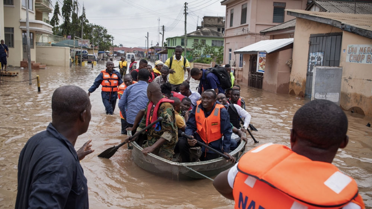
The June 2026 floods killed 10 people and displaced thousands, with communities including Kaneshie, Odawna, Adabraka, Circle, Aboabo, Lapaz, Alajo, Mallam, and other areas submerged .
The Human Cost
Behind the statistics are real people whose lives are disrupted repeatedly. A study on everyday flood hazards in Accra’s periphery found that heavy rain events routinely cause overflow from streams and drains, inundate road segments, and transform interior roads to sludge . Residents face:
-
Delayed mobility: Spending extra hours in transit while waiting for water to recede .
-
Postponed mobility: Having to stay home and postpone planned trips for one or several days .
-
Lost work hours and income: Those in the most interior areas, furthest from large all-weather main roads, are most severely affected .
The Fixes That Are Being Tried
Despite decades of failure, new solutions are being attempted:
The GARID Project: Performance-based dredging along the Odaw Channel, with drainage and road improvement works progressing in Alogboshie (58% complete), Akweteyman (62%), and Nima (65%) .
The Flood Mitigation Task Force: A phased dredging, desilting and demolition exercise at flood-prone locations across Accra, including the Tesa Dam in East Legon where structures built illegally along the banks were demolished .
Wetland Restoration: Plans to demolish buildings on six Accra wetlands to restore natural water retention capacity .
Mandatory Rainwater Harvesting: The GhIE has recommended that every estate developer should be compelled by law to incorporate rainwater harvesting infrastructure capable of temporarily storing storm water during rainfall events. The Institute argues that this is “the only way we can stop flooding in Accra now” .
Year-Round Desilting: The President has directed that desilting and dredging of drains should become a continuous nationwide exercise, not a seasonal response .
ASJ Conclusion
Accra’s flooding crisis is a story of repeated failures over more than six decades. The causes are well-documented: geography, loss of retention ponds, encroachment on wetlands, inadequate drainage, and institutional fragmentation. Climate change is now accelerating the crisis, with rainfall intensity doubling in just three years.
The long-term solution requires a radical shift—from downstream, conveyance-based engineering to upstream, decentralised, nature-based stormwater management . This includes restoring wetlands, enforcing planning regulations, mandating rainwater harvesting, and addressing the institutional fragmentation that has prevented coordinated action.
As President Mahama stated, “We must tackle this challenge from both an engineering and an enforcement perspective” . The question is whether this time, the response will be different.
Quick Facts
| Topic | Details |
|---|---|
| First Major Flood Record | 1960 (and 1973 record of Odaw overflow) |
| Worst Disaster | June 3, 2015 — 150–250 deaths |
| June 2024 Rainfall | 85mm |
| June 2025 Rainfall | 172mm |
| June 2026 Rainfall | 333mm |
| June 2026 Death Toll | 10 confirmed |
| Historical Death Toll | 3,000+ from 1935–2023 |
| Key Cause | Loss of natural retention ponds; water travel time from Aburi to Accra reduced from 12 hours to 1 hour |
| Current Fix | GARID Project, Flood Mitigation Task Force, wetland restoration |
Frequently Asked Questions
1. When did Accra’s flooding problem begin?
The flooding problem has been documented since at least 1960, when the Daily Graphic reported on flood devastation in Accra. Major floods were recorded in 1973, 2007, 2010, 2011, 2015, and 2020 .
2. What caused Accra’s worst flood disaster?
On 3 June 2015, after hours of torrential rain, floodwaters carrying a film of fuel reached a GOIL filling station at Kwame Nkrumah Circle where hundreds had taken shelter. The station exploded, killing an estimated 150 to 250 people. The day is now commemorated annually as National Flood Disaster Day .
3. Why does Accra keep flooding despite drainage projects?
The root causes are multiple: rapid urbanization and loss of natural retention ponds, encroachment on wetlands, poor drainage infrastructure, institutional fragmentation, and climate change accelerating rainfall intensity. Experts argue that drainage works alone will not solve the problem unless waterways are protected and residents adopt better practices .
4. How has climate change affected Accra’s floods?
Rainfall has increased dramatically. June 2024 recorded 85mm, June 2025 recorded 172mm, and June 2026 recorded 333mm. Rain now falls on about 22 of 30 days in June, leaving little time for drainage systems to recover .
5. What are natural retention ponds and why do they matter?
Natural retention ponds were wetlands and low-lying areas that absorbed rainwater and slowly released it, reducing flood speed. Most have been destroyed by urbanization. Water that used to take 12 hours to travel from Aburi to Accra now reaches the city in about one hour .
6. What is the GARID Project?
The Greater Accra Resilient and Integrated Development (GARID) Project is a multi-sector urban resilience initiative addressing flooding through drainage improvements, sediment dredging, transport infrastructure upgrades, and solid waste management. As of January 2026, 90,936 cubic metres of sediment had been dredged from the Odaw Channel .
7. What is the Flood Mitigation Task Force?
A government task force led by the Deputy Chief of Staff and the Minister for Works, Housing and Water Resources that is conducting phased dredging, desilting, and demolition exercises at flood-prone locations across Accra, including the Tesa Dam in East Legon .
8. What is the long-term solution experts recommend?
The GhIE advocates a shift toward decentralised, nature-based stormwater management systems that mimic natural hydrological processes, including rainwater harvesting, permeable pavements, bioswales, rain gardens, green roofs, and detention systems. They also call for a National Rainwater Harvesting Policy and stronger enforcement of land-use regulations .
9. Why is institutional fragmentation a problem?
Responsibility for drainage and flood control is spread across multiple agencies, while administrative boundaries often do not align with natural drainage basins. This makes coordinated catchment-wide planning difficult and has weakened efforts to address the crisis effectively .
10. What is being done to restore wetlands?
The government has identified six wetlands in Accra that must be restored and has announced plans to demolish buildings encroaching on these areas. The Deputy Minister has warned those who purchased land in these areas to seek redress from those who sold the properties, stating that “the government is going to take them and use them for the right purpose”
Source: Accra Street Journal
Last Updated on August 31, 2026 by Samuel Kwame Boadu
Disclaimer: Some content on Accra Street Journal may be aggregated, summarized, or edited from third-party sources for informational purposes. Images and media are used under fair use or royalty-free licenses. Accra Street Journal is a subsidiary of SamBoad Publishing Hub under SamBoad Business Group Ltd, registered in Ghana since 2014.
For concerns or inquiries, please visit our Privacy Policy or Contact Page.

Samuel Kwame Boadu is a Ghanaian media entrepreneur and storyteller with a passion for amplifying urban voices and uncovering everyday truths. He is the Editor-in-Chief and Founder of Accra Street Journal, a dynamic digital platform dedicated to capturing the pulse of Ghana’s capital—its people, culture, challenges, business, sports and innovations.